Kizuna Solutions: Good Practice with Japanese Companies
2026.2
ArkEdge Space in South America/Central Asiaⅰ
Turning Space Infrastructure into Practical Tools
– Co-creating Solutions from Space to Close Information Gaps –ⅱ
| Summary | ArkEdge Space Inc. integrates satellite, ground-based IoT, and local data into actionable intelligence to tackle national challenges ranging from agriculture and disaster management to environmental protection through co-creation with local partners. Recently we have seen some progress in Paraguay, Brazil and Central Asia, for example. By building a new space infrastructure and using an agile software platform to provide accurate information and traceability that helps close the global information gap, the company is shaping a future that supports industries and everyday life around the world. |
|---|---|
| Reference | Our Projects Products and Services Empowering Everyone with Satellite Data (Presentation material) |
The Hidden Costs of Information Gaps
Many regions around the world still lack basic infrastructure for information and communication. Without access to essential data, people are unable to make informed decisions, and efforts in environmental conservation or sustainable production may fail to reach markets, leaving communities at a disadvantage. This “information gap” reinforces structural inequality and hampers local economic development and self-reliance.
These inequalities are especially evident in water management and key industries. Floods, droughts, and wildfires directly impact agriculture and disaster preparedness, while climate change disrupts traditional practices across multiple sectors: farming and forestry in Paraguay and Brazil, and mineral industries in Central Asia. Without accurate information and traceability, countries risk losing competitiveness in global markets, with significant economic consequences. Logistics disruptions, such as lowered river water levels, further affect entire industrial structures. Satellite and space-based data can visualize these hidden inequalities, providing a vital tool to support sustainable industry and resilient communities worldwide.
Harnessing Space Infrastructure for Solutions
 |
|---|
Remote Sensing and ground data collection via satellite |
 |
|---|
Satellite VDES (VHF Data Exchange System) is |
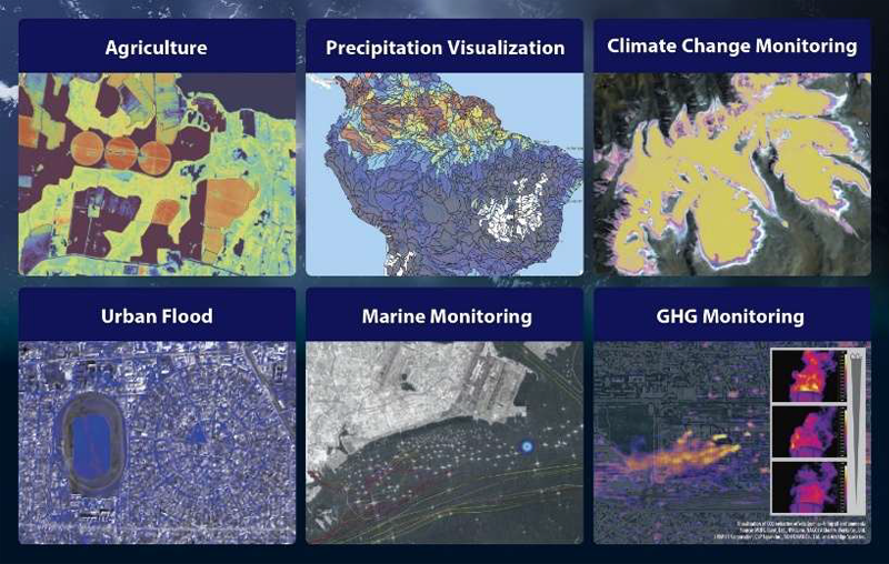
ArkEdge Space Inc. is bridging the global information gap by integrating satellite data, ground-based IoT, and local on-site data. This innovative approach transforms hard-to-access data on agriculture, disaster management, and environmental monitoring into actionable intelligence that empowers communities and industries. Our system has a wide application to address various issues by region. In Paraguay, it supports farming and flood response; in Brazil, it monitors oceans and forests; across Central Asia, it improves water resources management and the monitoring of glacial lakes. Because each region faces unique challenges, the company works closely with local partners to co-design solutions that fit local needs. By turning space infrastructure into a practical tool, the company is building safer societies, smarter industries, and more sustainable development worldwide.
From Space to Society: Using Satellite Data for Real-World Challenges
 |
|---|
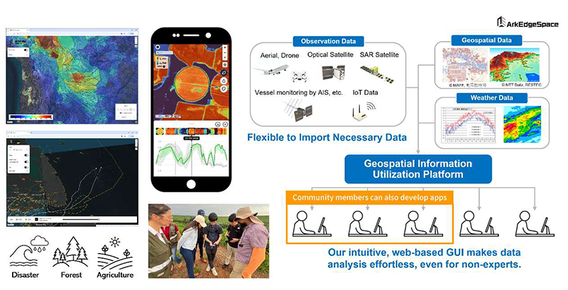
Geospatial Information Platform "ArkEdge Insights®" |
Paraguay: Smart Farming from Space
Paraguay’s vast farmlands face challenges in gathering agricultural data and assessing disaster risks due to limited ground infrastructure. ArkEdge Space Inc. is tackling this with satellite-powered solutions that deliver critical insights to farmers and authorities.
In November 2025, the company launched an agriculture-focused app at a ceremony attended by government and farming stakeholders. The app supports the national agricultural production certification system and monitors land conditions, and its use is spreading among large-scale farms. Integration with the National Plant and Seed Quarantine and Quality Control Agency’s databases is under consideration.
ArkEdge Space Inc. is also developing a disaster and water management app, using 65 years of hydrological data to build predictive river-level algorithms and planning IoT sensor deployment. A hazard map and evacuation route app is being explored, incorporating geospatial and incident data from the Emergency Management Agency.
Until now, agricultural operations have been managed based on empirical knowledge, but climate change is undermining this approach. These satellite-powered solutions address this fundamental challenge, promoting sustainable agriculture while strengthening Paraguay’s resilience to environmental risks.
Brazil: Protecting Natural Wealth from Space
Brazil boasts vast maritime areas and diverse ecosystems, yet monitoring these environments remains challenging due to accidents alongside offshore oil development, illegal mining, and forest degradation. Offshore oil spill detection, in particular, is difficult from the ground, and requires rapid and accurate monitoring.
In response, ArkEdge Space Inc., in collaboration with Space Shift Inc. and LocationMind Inc., has developed an integrated monitoring solution that combines satellite imagery for oil spills and vessel detection with AIS (Automatic Identification System) data. This system, developed with requests and data from the Brazilian Institute of Environment and Renewable Natural Resources (IBAMA), is currently being pilot-tested through a dashboard. The initiative is expected to accelerate efforts to strike a balance between offshore oil platform development and environmental conservation in biodiversity-rich regions.
The company is also exploring broader collaborations with IBAMA on multiple fronts: environmental restoration through agroforestry, monitoring degradation and recovery in the Cerrado biome, qualitative observation of marine oil pollution, mangrove conservation, and illegal mining surveillance. By combining satellite data with AI analytics, the company aims to build next-generation infrastructure to safeguard Brazil’s environment.
Kyrgyzstan and Central Asia: Climate Intelligence
In Central Asia, mountain ranges such as the Tien Shan are considered some of the regions most rapidly affected by climate change. Yet the vast land area, limited physical access, and insufficient communication infrastructure make it difficult for countries to fully understand environmental changes through traditional ground-based observations alone.
To address this challenge, ArkEdge Space Inc. is exploring a next-generation climate monitoring and forecasting system that integrates satellite remote sensing, ground-based IoT data, and hydrological simulations. Working with research partners, the company is developing high-precision hydrological models capable of reproducing mountain snowpack levels and melt patterns.
This integrated approach aims to support disaster monitoring and prediction, the revision of infrastructure design standards, and the optimization of water resource management—all essential for climate adaptation. Across the expansive Central Asian region, a satellite-and-IoT-powered “risk visualization infrastructure” is expected to become a transformative tool for building resilience.
“Co-Creation”: The Motto for ArkEdge Space Inc.
At ArkEdge Space Inc., our fundamental philosophy is “Co-Creation”: we create solutions together with local communities. Satellite data alone cannot solve complex social and environmental issues, but true power emerges only when it is combined with on-the-ground knowledge.
In Paraguay, government agencies and the Navy have shared 65 years of river-level data, enabling us to merge historical records with satellite observations and build predictive machine-learning models. In Brazil, authorities have provided oil-spill incident data that we pair with satellite imagery to enhance detection accuracy and strengthen environmental protection.
Our approach unites local datasets, satellite intelligence, advanced analytics, and partner expertise, allowing us to design applications optimized for each region’s unique realities.
With our agile software platform, we integrate local feedback quickly and deliver solutions that scale.
Solving Global Challenges through Co-Creation
The company is currently transitioning from the satellite development and manufacturing phase to a focus on establishing mass production, quality control, and operational systems. Simultaneously, collaboration with partner companies, international organizations, and developing nations is accelerating. This process involves confronting diverse challenges beyond technical hurdles, including regulatory compliance, international negotiations, understanding local conditions, and restructuring business models.
By overcoming these challenges, ArkEdge Space Inc. has already received feedback from agricultural stakeholders on its agricultural support application in Paraguay, stating, “We feel it has significant potential to contribute to improving quality, enhancing fieldwork efficiency, and ensuring transparency in soybean seed production. We will continue to cooperate in its future development.”
Beyond these activities lie a future where societies overcome challenges caused by infrastructure bottlenecks, ensuring equal access to information, opportunity, and safety for all. Through this co-creation model, the company advances space-based infrastructure, connects previously isolated regions, and creates new opportunities, while helping communities across this planet build a safer, more resilient future.
 |
|---|
|
Contact Mr. SUZUMOTO Ryo |
|---|
- This document has been prepared based on information deemed reliable by JPRSI. No guarantee is made as to its accuracy or completeness.
- Any profit or loss resulting from actions taken based on this document is the sole responsibility of the party taking such actions, and JPRSI shall not be held liable.
- You are free to link to this document. If you quote or cite any part of this document by other means, please clearly state "JPRSI (Japan Platform for Sustainable Infrastructure) website" as the source.
ⅰ This article was prepared by JPRSI in collaboration with ArkEdge Space Inc., and is published with the company’s permission.
ⅱ Geospatial Information Platform "ArkEdge Insights®"