Flood Risk 3D-EYE
Yachiyo Engineering Co., Ltd.
Technology / Service Summary
"Flood Risk 3D-EYE" enables the intuitive identification of inundation risks caused by floods and heavy rain.
Purpose
In recent years, the increase of heavy rains and flooding caused by climate change has been a concern. However, only few companies establish their own business continuity plans (BCP) covering flood risks. "Flood Risk 3D-EYE" will be a simple and reliable decision support tool for community or company to make a BCP.
Feature
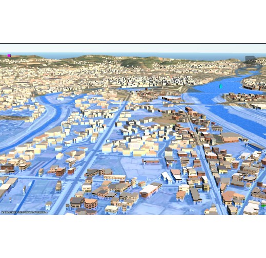
"Flood Risk 3D-EYE" is visual and easy-to-understand tool to understand inundation risk.
Effect
■ Risks are easy to understand!
Hazard maps only show the depth of flooding over a wide area, and it is not possible to intuitively understand the height to which a particular company's factory or other facility may become inundated. "Flood Risk 3D-EYE" allows you to intuitively understand the extent of possible flooding, making it effective for developing evacuation methods and response measures.
■ Smooth on-site usage!
Our technology has made it possible to easily operate the service on a smartphone or tablet. This will allow you to examine evacuation routes and response measures as you check inundation data while on site.
Controlled Substance
Reference
Applicable Regions / Countries
- Japan
- Southeast Asia
- Central/South Asia
- China/ East Asia
- Middle East
- Africa
- Oceania
- Europe
- Central/South America
- ASEAN countries
Indonesia,Cambodia,Singapore,Thailand,Philippines,Brunei Darussalam,Viet Nam,Malaysia,Myanmar,Lao PDR
Accomplishments
Cannot be posted due to confidentiality
Related SDGs Goals
- 9. Industry, Innovation and Infrastructure
- 11. Sustainable Cities and Communities