Satellite-Based Geospatial Platform for Disaster, Environment, and Climate-Resilient Agriculture
Technology / Service Summary
ArkEdge Space aims to "Empower people with satellites for a prosperous future" and engages in a wide range of businesses, from mass production of various small satellites to providing solutions through satellite utilization.
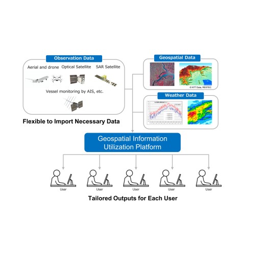
In delivering solutions, we are developing methods to detect and analyze diverse environmental changes and risks by integrating geospatial information from satellite remote sensing and ground-based sensors, along with a platform for their effective use. Currently, we are conducting demonstration projects in Global South regions such as South America, Central Asia, and Africa, addressing applications including oil spill monitoring, climate-resilient agriculture, water resource and forest management, and GHG observation.
Purpose
We are developing methods to detect, identify, and analyze environmental changes and risks by combining data from various satellites and ground sensors.
Feature
By leveraging advanced web technologies and AI, we are developing a geospatial information platform that automatically collects, processes, and analyzes diverse data, enabling everyone, even non-experts, to easily visualize key information through simple operations and help businesses assess and disclose natural capital risks and opportunities, as well as support conservation efforts.
Effect
Adaptation to Climate Change
Controlled Substance
Applicable Regions / Countries
- Japan
- Southeast Asia
- Central/South Asia
- China/ East Asia
- Middle East
- Africa
- Oceania
- Central/South America
- ASEAN countries
Indonesia,Cambodia,Singapore,Thailand,Philippines,Brunei Darussalam,Viet Nam,Malaysia,Myanmar,Lao PDR
Reference URL
- ArkEdge Space Inc. Satellite Remote Sensing
- ArkEdge Space signs MoU with Paraguayan Space Agency ―Space Industry Cooperation on Satellite Constellation for SDGs and Space Utilization and Sustainable Development through Space Data Platforms―
- ArkEdge Space Signs MoU with Three Organizations in Kyrgyzstan and Tajikistan — Launching Joint Research on Climate Change and Regional Issues Using Satellite Data —
Related SDGs Goals
- 1. No Poverty
- 2. Zero Hunger
- 3. Good Health and Well-being
- 6. Clean Water and Sanitation
- 7. Affordable and Clean Energy
- 9. Industry, Innovation and Infrastructure
- 11. Sustainable Cities and Communities
- 13. Climate Action
- 14. Life Below Water
- 15. Life on Land


